
The first Mpact Transit + Community Conference* is headed to Phoenix this fall! There’s a lot to know about Phoenix and the Valley of the Sun. Here’s a round up of some key facts about the region – a snapshot to pique your interest. We know there’s a lot more to learn! Come to the conference in November to get a first-hand picture of the region and learn from peers around the country about the latest approaches to transit, mobility and development projects.
*The conference now known as Mpact Transit + Community was formerly Rail~Volution. We announced our new name and identity at Rail~Volution 2022 in Miami. Read all about it here.
PHOENIX & THE REGION AT A GLANCE
The Phoenix-Mesa-Scottsdale Metropolitan Statistical Area (MSA) includes all of Maricopa County and Pinal County. It is comprised of more than 20 municipalities. The Phoenix-Mesa-Scottsdale MSA has a lower median age (36.9) than Arizona (38.0) and the U.S. as a whole (38.2), even though Arizona, and the Phoenix-Mesa-Scottsdale MSA in particular, are among the leaders in retirement communities nationally.
In the nation, Phoenix ranks as:
- 5th Most Populous City in the U.S. as of July 1, 2021 (US Census Bureau)
- #17 in Fastest-Growing Places (US News)
- #26 in Best Places for Business and Careers (Forbes)
- 3rd Largest Metro Area for Semiconductors Manufacturing Employment (Greater Phoenix Economic Council)
- #1 Hottest City in the U.S. (UN Foundation)
- 9th Highest Annual Pedestrian Fatalities 2015-2019 by 2019 counts (NHTSA’s National Center for Statistics and Analysis)
The region is known for its iconic sunrises and sunsets, desert climate and saguaro cacti. Did you also know:
- The Phoenix metro area has 180 miles of canals. The Hohokam originally constructed 1,000 miles of canals.
- Phoenix is home to South Mountain Park & Reserve, one of the largest city parks in the country at over 16,000 acres.
- Frank Lloyd Wright’s Taliesin West is in the Valley of the Sun. Also nearby are Cosanti and Arcosanti, constructed by Paolo Soleri, an architect who worked with Wright.
TRANSIT & MOBILITY
Transit in the Phoenix metro has experienced significant growth over the past two decades. In December 2008, the region’s first light rail line opened and it was the longest modern starter line at 20 miles. Since then, three extensions totaling 8 miles have been added with more underway. The light rail system connects the region to the cities of Phoenix, Tempe and Mesa, as well as to Phoenix Sky Harbor airport.
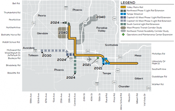
Existing light rail and future expansions to the system (Valley Metro)
Valley Metro is the regional public transportation agency in metro Phoenix. Valley Metro is also the chair of this year’s Local Host Committee which is composed of local leaders to help showcase the region’s story at the conference. Transit options available in the region include:
- 28 miles of light rail connecting 38 stations
- 100 bus routes, including local, RAPID and express buses as well as neighborhood circulators and rural route
- 3 miles of streetcar spanning 14 stops in Tempe
- Microtransit in cities including Avondale, Chandler, Goodyear and Surprise
- Other services including ADA/paratransit, RideChoice, communter vanpools, online commute matching system, and employer assistance in creating and implementing travel reduction plans
PROJECTS IN PROGRESS
Valley Metro has three light rail projects underway:
- Northwest Extension Phase II project: The project will extend the light rail 1.6 miles across three stations and end near the former Metrocenter Mall. The Metrocenter Station will be the light rail’s first elevated station. There are plans to redevelop the former mall and add housing, retail, hotels and a park.
- South Central Extension/Downtown Hub: The 5.5. mile extension will connect South Phoenix to the regional light rail system. There will be 8 new stations and a transit hub. This project was developed with significant community involvement.
- Capitol Expansion: The 1.4-mile extension will connect with the existing Valley Metro Rail system in downtown Phoenix to the State Capitol. The goal is to energize the downtown and Capitol areas.
Bus rapid transit is coming to Phoenix. Voters in the City of Phoenix approved a proposition in 2015, “creating the 35-year street and transit plan known as Transportation 2050 or T2050. Bus Rapid Transit (BRT) was identified as a key component of T2050 to continue expanding [the] city’s high capacity transit network.”
There are several bicycle and pedestrian projects in local cities:
- Phoenix has many ongoing bike lane projects. Check out the City of Phoenix’s Street Transportation Department account on Twitter, @StreetsPHX. Phoenix was also recently awarded a $25m RAISE Grant to build the Rio Salado Bike/Ped Bridge.
- Tempe has a number of projects to add bike lanes and improve conditions for pedestrians. Their bicycle network is called BIKEiT.
- Scottsdale is in the design phase for the 68th Street Bike Lanes project which will complete north/south regional bike lanes for the major roadway.
- Mesa is working on a few shared use path projects.
Additionally, several cities in the county are recognized as Bicycle Friendly Communities by the League of American Bicyclists:
- Phoenix is Bronze.
- Mesa is Silver.
- Tempe, Tucson and Scottsdale are Gold.
The Phoenix region is embracing autonomous vehicles. Waymo is creating a 180-square-mile service area by connecting two existing coverage areas. The area includes most of Tempe and parts of Old Town Scottsdale and Mesa. Autonomous public transportation is now accessible for residents of Sun City, an Arizona retirement community. May Mobility and Via are providing two autonomous Toyota Siennas with sponsorship from AARP.
TRANSIT-ORIENTED AND ECONOMIC DEVELOPMENT
The growth of transit across the region has spurred development:
- The light rail system has supported $14.4 billion in public and private investment along the corridor since its opening.
- 473 projects, including 35,000+ residential units have been built along the LRT.
- The City of Phoenix created the South Central Community TOD Plan which prioritizes the community’s vision with a strong emphasis on minimizing displacement in the historically disinvested and redlined community. A previous Mpact Podcast episode with Elias Valencia, a City of Phoenix planner, and Victor Vidales, a local resident and business owner, talks about the creation of the plan.
- The City of Phoenix Walkable Urban Code regulates development in proximity to light rail stations.
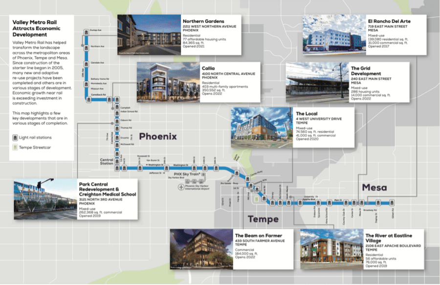
Economic development and light rail (Valley Metro)
In Tempe, Culdesac, a car-free built-from-scratch neighborhood, offers a walkable community in the Valley of the Sun. The 17-acre development has connections to transit and boasts over 700 apartments for rent, 44,000 square feet of retail, over 2 miles of paths to walk and bike.
HEAT, CLIMATE AND SUSTAINABILITY
The region is actively experiencing the effects of climate change. In addition to being the hottest city in the country, Arizona is nearly 15 years in drought. Regional stressors call for innovative solutions:
- The Cool Pavement Program involves applying cool pavement coating to roadways which reduces surface temperatures. According to the City of Phoenix, after one year of the program, “Cool pavement revealed lower surface temperatures at all times of the day versus traditional asphalt.” The program received a Crescordia Award from Arizona Forward in the category of Climate Action Solutions.
- The Cool Corridors Program goal is to plant 200 trees per mile for a total of 1,800 new trees across nine areas in Phoenix. This program supports the city’s Tree Equity by 2030 Pledge where the City of Phoenix and the Arizona Sustainability Alliance are leading a coalition of partners to preserve and plant urban forests and create “Cool Corridors” in heat vulnerable neighborhoods.
- Stations and buses in the region are designed with the desert climate in mind. Buses feature glass that blocks 99% of UV light helping keep the inside of the bus 12 degrees cooler compared to buses with traditional glass. At light rail stations, screens with vines growing on them act as public art and shade.
- The Heat Relief Network is a partnership between the Maricopa Association of Governments, municipalities, nonprofit organizations, the faith-based community, and businesses that provides cooling centers, hydration stations and water donation sites.
WANT TO KNOW MORE?
Check out some of the following links: